
Trail of Alternates, Pie Town to Grants, NM
- Savannah Robinson
- Jun 1, 2023
- 8 min read
Updated: Jun 6, 2023
Days 17 - 20
May 28 - June 1, 2023
Miles 335.8 - 421.7

My first day out of Pie Town was going to be a short day, only about 16 miles. So I got to sleep in and enjoyed a slow morning getting ready. On my way out, I stopped in at the same restaurant as yesterday, the Ohana Cafe, for a slice of pie. They generously give CDT hikers a free slice of pie. I got a cherry cream pie. It was the first time I ever had a cream pie before and oh wow was it amazing. Pie Town really does know their pies. Did I say pie enough?

As I ate my pie, I thought about what route to take through this next section. There was the main "official" route of course, but there were two alternate options that could be combined in a few different ways. The CDT really is more of a "Choose your own adventure" type of trail, rather than one set course like the PCT and AT. I sat and thought about my course in trepidation. None of the options sounded great and there would be a lot of road walking no matter which way I went. I ate the last bite of my cream pie and no longer had an excuse to linger.

The road walk was not nearly as bad as I thought it would be. Since it was a short day, I was in no rush. It was a dirt road so it wasn't as bad as walking on pavement. I finished listening to my audiobook and then listened to music the rest of the way. There wasn't much to look at on the walk. It was quite uneventful, but it was nice to just walk and get to zone out completely for a while.
I made it to the TLC ranch just after 4pm. There were a couple reasons why I was only hiking this far today. I wanted to give my knee a bit more rest with another half day of walking. Also, this ranch provided water and camping for CDT hikers along an otherwise dry and privately owned stretch. And very unfortunately, not even a week ago, some CDT hikers were shot at by an unknown someone just seven miles north of here at a water source. Thankfully nobody was harmed. But I wanted to completely avoid that source and also didn't want to hike by there as it got dark. So I stayed at the small haven of TLC ranch and was very grateful for their kindness.

I set up my tent just before it began to rain. It was only a small sprinkle, but it still felt lucky. Soon, Kittyhawk and Carmen San Diego walked up. We all talked and ate dinner together before retiring to bed. A mouse kept running around, looking very interested in our food. I heard it rummaging through the trash during the night.
I got an early start the next day, or at least I tried to. I had about 25 miles until my next water source so I carried just over 5L of water. For reference, 1L of water weighs 1Kg, and 1Kg is about 2.2lbs. So 5L of water weighs about 11lbs. My pack felt very heavy with this extra weight. But the first 12 miles of the day were along the same dirt road, so that wasn't too bad.

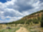
I decided to take the alternate route through the Cebolla Wilderness. I had been hesitant about this route because some people had described the trail as being the loose shifting sand, where you work twice as hard to go half as fast. I had no idea what they were talking about. I encountered that type of track a few times for just a couple steps - so little that I wouldn't have even thought to mention it if I hadn't been looking for it.

The first half of this trail up through the canyon was a very cool historical walk. I passed by the Dittert site, a ruin of a rock structure left by the Anasazi people sometime between 1,000 - 1,300 years ago. I saw an obsidian arrowhead. There is an old ruined wooden house built further up into the canyon. And as I hiked up out of the canyon over the hill, I passed by some pictographs and petroglyphs. Pictographs are painted on while petroglyphs are carved into the rock. The silhouette of hands outlined in yellow were painted onto a large boulder overlooking the canyon. Please, if you ever find ancient artifacts, art, structures, etc., do not touch or remove them. Oils from our hands can damage rock art. It was very moving thinking about the different people who have lived and moved through this area throughout time.


I hiked a little further up this hill before it leveled out and started going downhill. It wasn't too steep, but my injured knee twinged a few times. Large clouds rolled in and shaded out the sun. The temperature was cool and I hiked longer than I intended to before taking a lunch break. It's hard not to take advantage of good weather.
I followed a dirt and sand road all the way out of Sand canyon to Highway 117. I stopped and finally got some water from a solar well. These solar wells pump water out of the ground using energy from the sun and pipe it into a large cattle trough. It had been overcast the past several hours, but when I arrived, the clouds parted and the sun caused the pipe to flow for a few minutes before being covered by clouds again. I was able to collect fresh clean water from the pipe rather than the stagnant water in the trough. It felt like a small miracle.

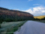
I had about four miles of roadwalking along the paved highway before I got to where I wanted to camp. It wasn't too bad and I found a way to enjoy it. There was a tiny storm that passed over me. It had been calm and warm, but all of a sudden a strong chilly wind whipped through and it started to rain. It lasted about seven minutes before it subsided and the sun came out again. Weird. Just keep on hiking I suppose.

I got to the South Narrows picnic area where I set up to cowboy camp on a concrete pad and made dinner. I took advantage of the picnic table and did a full round of leg stretches. I had a really great day and was looking forward to tomorrow.

I woke up early and packed up my stuff quickly. This picnic area was day use only and I wasn't actually supposed to be camping here. Instead of walking along the highway again, I took the Narrows Rim trail that paralleled the road from the rocks above. It was a beautiful trail and I enjoyed it so much. I got to see the sunrise behind the clouds over the cliffs and it was stunning. I had great views of the large lava field below in El Malpais National Monument.

This trail is supposed to be an out-and-back, but it has continued on further to a talus slope where you can safely rock scramble all the way down to the bottom, which is what I did. I had a lot of fun coming down. This took me right in front of La Ventana natural arch. I spent some time admiring this arch and the surrounding cliffs before getting back to the highway for another roadwalk.

Just under three miles along the highway took me to the trailhead of the Acoma-Zuni trail. This was the end of my first alternate route and where I connected back to the official CDT route. Although this trail was east-west oriented, I would technically be doing this next section along the trail southbound, opposite of my actual direction.

The Acoma-Zuni trail is an ancient footpath that the indigenous peoples created to connect different pueblos. It is marked by stacked rock cairns as no foot tread is left on the lava flows it traverses. This trail was challenging and beautiful. It was slow going as I had to pause frequently to find the next cairn. Also crossing the lava flows is difficult and hard on the feet. But it was stunning. I'm really glad I took this route as part of my CDT journey. I even got to see an Eastern Collared Lizard. I think this is my new favorite lizard - it has such a beautiful blue/green coloration.

The challenging Acoma-Zuni trail brought me to another alternate trail. This path took Bonita Canyon and Zuni Canyon roads into Grants, NM. I would get to walk along dirt roads rather than more of the paved Highway 117.

As I walked the first few miles of Bonita Canyon rd, I didn't feel very good. I felt a little dizzy and almost nauseous. I figured I probably hadn't drank enough water throughout the day. I got to a windmill well and collected water from the flowing pipe. The canyon had such a constant breeze it was hard to imagine that pipe ever not flowing. I found some shade under a small tree and sat and drank. A few minutes of shaded rest and chugging water and I felt like new again.

The rest of my walk for the day through the canyon was beautiful, but rather uneventful. My right shin started to ache and I was tired, but I pushed on. I experienced that type of pain before and it always went away overnight. I got to the next water source and collected enough for the night and all of tomorrow. A little further on, I found a place to pitch my tent. It was a long day and I was ready to sleep.
I had a short day into town the next day, only about 11 miles. Except it felt like much longer. That shin pain that started yesterday had not gone away. My leg felt stiff and every step on it was painful. I enjoyed the first part of the morning, watching the sun light up the canyon walls. But soon enough the pain in my right leg became overwhelming and it was a struggle to distract myself from it.

The dirt and gravel road turned into pavement. I walked into the residential area outside of Grants. I had heard reports of loose dogs here and sure enough one showed up. It barked at me and made its way towards me. Luckily, a neighbor with a deep once yelled at the dog and it left me alone. I limped my way into Grants and made my way towards the Lava Flow Hostel where I had booked a bed for two nights. I needed to rest and planned to take a day off tomorrow.
The same couple I had met back at Jordan Hot Springs were at the hostel and I got to hang out with them. It was great to see them again. My right shin was swollen and inflamed and I quickly sat down in a chair and hardly moved for eight hours. Pancake showed up too. I was so happy to see her. She was spending the night here before getting off trail tomorrow - she had just finished her section hike.

I made a telehealth appointment for tomorrow with a thru hiker oriented physical therapist. The pain in my shin was some of the most intense pain I had ever felt and the walk into Grants was horrible because of it. I needed to take care of it before I got back out there. Depending on what she says, I may need to take more than one day off here.